

Our Services
At Mylokations, we specialize in providing innovative geospatial services and immersive solutions that bring your projects to life. Whether you're navigating complex spatial data, planning infrastructure, or managing natural resources, our expertise empowers you with the insights to make informed decisions.
In addition to our core geospatial services, we offer Virtual Tours, Modelling, and Digital Twin solutions that redefine how real-estate and spaces are showcased. Our interactive Virtual Tours provide an engaging way to explore spaces, while our modelling services create detailed, realistic representations of structures and landscapes.
With a commitment to precision, creativity, and client satisfaction, we transform complex data into actionable insights and dynamic visual experiences.
Explore our range of services to see how we can elevate your projects with cutting-edge technology.
Virtual Tours

- Real Estate Virtual Tours.
- 3D Digital Twin(renderings of exteriors and interiors)
- Construction and Facility Monitoring.
3D Modelling
- High-Precision Digital Models.
- Versatile Applications in architecture, real estate marketing, construction planning, and urban design.
- Photorealistic renderings for client presentations.
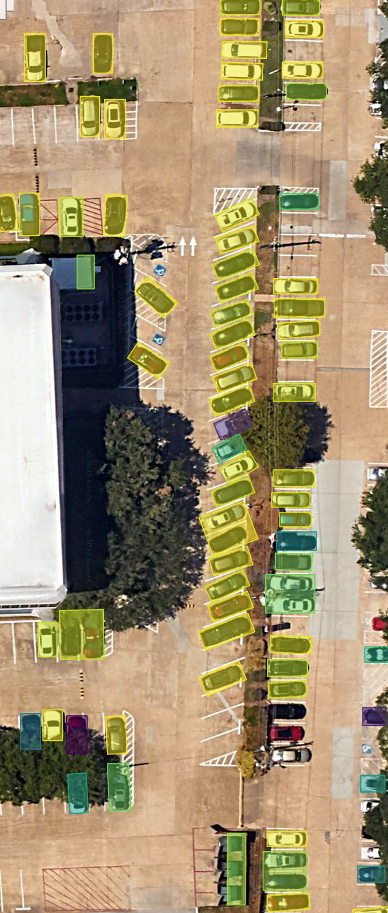
AI-Powered Image Detection
- Automated identification of solar panels from drone imagery.
- Solar potential analysis for rooftops and buildings.
- Detection and classification of vehicles in aerial & drone imagery.
- Estate Urban planning, traffic management, and parking analytics.
Surveying and Land Measurement
- Precision land surveying (construction, agriculture, and real estate).
- Boundary surveys and topographical surveys.
- Use of LiDAR, drones, and GPS technologies for accurate measurements.


Mapping and Cartography
- Creation of detailed maps for various purposes (topographic, thematic, cadastral, etc.).
- Customized digital and printed maps.
- 3D and interactive map development.
Web and App Development
- Development of geospatial applications for mobile and desktop.
- Geospatial APIs / Data integration into third-party platforms.
- Open-source GIS customization and support.
- Dashboards and visualizations for spatial data insights.

Location Based Services
- Geofencing and location analytics for retail and marketing.
- Site selection, navigation, and routing solutions.
- Real-time tracking for logistics and supply chain management.
- Route optimization and traffic analysis.